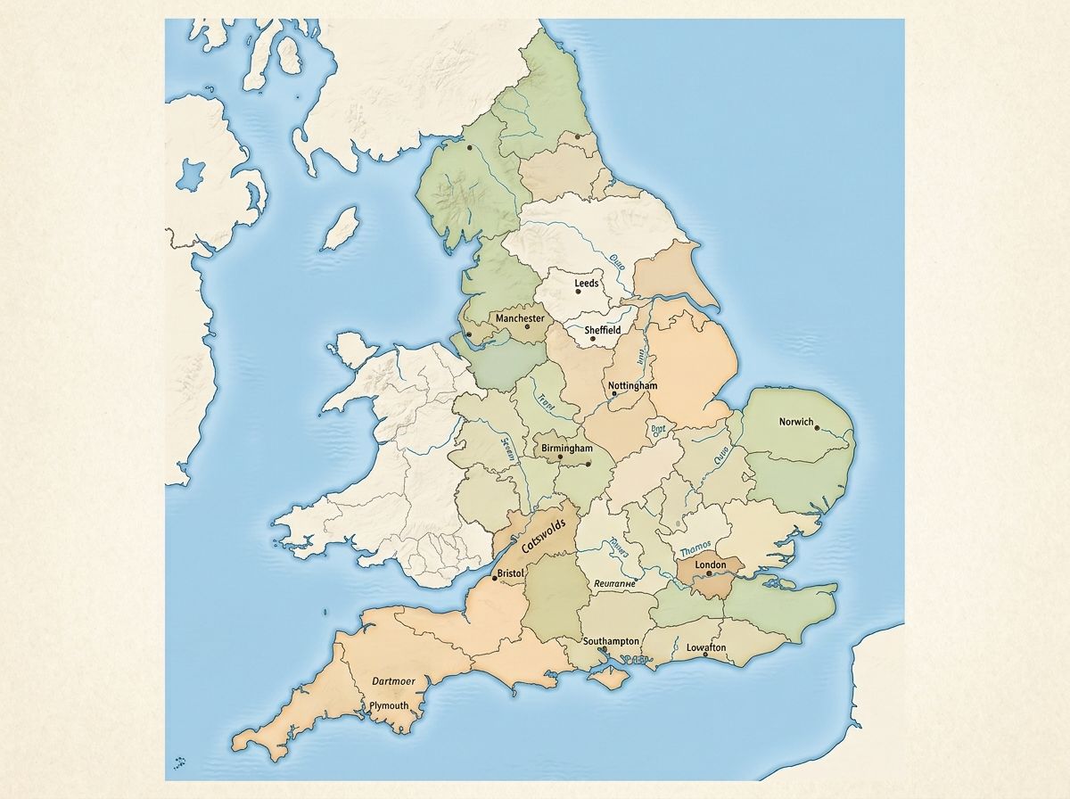
If you’re after a map of England, the quickest way to picture it is this: England is the largest of the four UK nations, sitting on the southern two-thirds of the island of Great Britain, bordered by Scotland to the north and Wales to the west. It covers roughly 50,301 square miles (130,279 square kilometres), according to the Office for National Statistics, and is home to an estimated 58.6 million people as of the mid-2024 estimate. Below, you’ll find a breakdown of England’s regions, counties, borders, cities and geography, plus where to find a proper map to use.
Whether you’re here for a school project, a house move, or planning a road trip, this guide covers every version of the map you might need.
Where Is England on the Map?
England sits in north-west Europe, on the island of Great Britain, which it shares with Scotland and Wales. Look at any map of England and you’ll see it bordered by Scotland along a line roughly from the Solway Firth to the mouth of the River Tweed, and by Wales to the west along Offa’s Dyke and the lower Wye Valley.
The country is surrounded by water on every other side: the North Sea to the east, the English Channel to the south (separating it from France), the Irish Sea to the north-west, and the Celtic Sea to the south-west. That coastline runs for around 2,015 miles, which explains why no part of England is more than about 70 miles from the sea.
The Nine Regions of England
England is officially divided into nine regions, used for statistics, planning and some government functions. From north to south, they are:
- North East (Newcastle, Sunderland, Durham)
- North West (Manchester, Liverpool, Preston)
- Yorkshire and the Humber (Leeds, Sheffield, York, Hull)
- East Midlands (Nottingham, Leicester, Derby)
- West Midlands (Birmingham, Coventry, Wolverhampton)
- East of England (Norwich, Cambridge, Ipswich)
- London
- South East (Brighton, Reading, Oxford, Canterbury)
- South West (Bristol, Plymouth, Exeter, Truro)
These regions don’t have their own elected governments (aside from London, which has the Greater London Authority and a directly elected mayor). They’re mainly used by the ONS, NHS bodies and transport authorities for reporting and planning purposes.
England’s Counties, Explained
This is where most map searches get confusing, because England has three overlapping layers of county:
Ceremonial counties are the 48 traditional counties tied to a Lord Lieutenant, used for royal and civic purposes. Think Kent, Yorkshire, Cornwall, Cheshire and Devon.
Metropolitan counties cover the big urban areas: Greater Manchester, Merseyside, West Midlands, South Yorkshire, West Yorkshire, and Tyne and Wear. These have combined authorities and mayors but no county council.
Local government (administrative) areas are the units that actually run services like bin collection, schools and social care. Many are unitary authorities that don’t map neatly onto the older county names, which is why “Rutland” and “Bristol” both count as counties in some contexts but not others.
If you’re filling in an official form and it asks for your county, use the ceremonial county name shown on Royal Mail’s postcode finder or GOV.UK’s address lookup tool.
Major Cities and Where They Sit
London is both England’s and the UK’s capital, with a population of around 8.9 million within Greater London, according to ONS mid-year estimates. Beyond the capital, the biggest cities by population are Birmingham, Manchester, Leeds, Sheffield, Bristol, Liverpool and Newcastle.
Geographically, most of England’s largest cities cluster in a band running from the North West through the Midlands, historically shaped by the Industrial Revolution and access to coal and canals. The South East and East of England, by contrast, are dominated by smaller towns and commuter belts feeding into London.
England’s Physical Geography
Away from the cities, England’s landscape splits roughly into two halves. The north and west are hillier: the Pennines run down the spine of northern England like a backbone, the Lake District holds England’s highest peak, Scafell Pike, at 978 metres (3,209 feet), and Cornwall and Devon offer rugged, cliff-lined coastline.
The Midlands and east are flatter and more agricultural, including the Fens around Cambridgeshire and Lincolnshire, some of the flattest, most fertile farmland in Britain. Rivers worth knowing for map purposes include the Thames (running through Oxford and London), the Severn (Britain’s longest river, flowing through Shropshire, Worcestershire and Gloucestershire), and the Trent, Mersey and Tyne.
England also has ten National Parks, including the Lake District, Peak District, Dartmoor and the New Forest, all worth marking on a map if you’re planning outdoor trips.
How England Compares to the Rest of the UK
England is the largest of the UK’s four nations by both area and population. It covers around 53% of the UK’s total land area but holds roughly 84% of the UK population, a gap that’s grown slightly as England’s population has increased faster than Scotland’s or Wales’s in recent years, per ONS figures.
Unlike Scotland, Wales and Northern Ireland, England doesn’t have its own devolved parliament or first minister. Laws for England are made at Westminster, though some powers sit with regional mayors (such as in London, Greater Manchester and the West Midlands) through devolution deals.
Where to Find a Map of England
For printing: GOV.UK, Ordnance Survey (os.uk) and the National Trust all offer free downloadable outline and county maps, useful for schoolwork or planning.
For accuracy on boundaries: Ordnance Survey is the UK’s official mapping agency and the most reliable source for county lines, footpaths and postcodes. A basic online OS map is free to view; detailed printed OS Explorer maps typically cost around £9.99 each in shops as of 2026, though prices vary by retailer.
For travel and road trips: Google Maps and the AA route planner are the simplest tools for driving directions, while National Rail’s interactive map is best for train routes.
For interactive exploring: the ONS geography portal lets you view England by region, county or local authority with live population data layered on top.
FAQS
How many counties does England have?
England has 48 ceremonial counties, plus six metropolitan counties and dozens of separate local authority areas that handle day-to-day services. The exact number depends on which type of county you mean, which is the main source of confusion when people search for a map.
What are the main regions of England?
England has nine official regions: North East, North West, Yorkshire and the Humber, East Midlands, West Midlands, East of England, London, South East and South West. These are used for statistics and some administrative purposes rather than for local government itself.
What is the population of England in 2026?
The most recent mid-year estimate from the ONS put England’s population at approximately 58.6 million in 2024, with growth continuing since. A fresh set of figures covering more recent years is expected from the ONS later in 2026.
What is the biggest county in England?
By area, North Yorkshire is the largest ceremonial county in England. By population, Greater London is the largest, though it’s technically classed separately from the ceremonial counties.
What is the highest point in England?
Scafell Pike in the Lake District is England’s highest mountain, at 978 metres (3,209 feet) above sea level. It sits within the Lake District National Park in Cumbria.
Does England border Scotland and Wales directly?
Yes. England shares a land border with Scotland to the north, running for around 96 miles, and with Wales to the west, running for around 160 miles. Both borders are long-established and haven’t changed in modern times.
What’s the difference between England, Great Britain and the UK?
England is one of four nations that make up the United Kingdom, alongside Scotland, Wales and Northern Ireland. Great Britain refers to the island shared by England, Scotland and Wales; the UK also includes Northern Ireland, which sits on a separate island.
Where can I get a free printable map of England?
GOV.UK, Ordnance Survey and the National Trust all offer free downloadable outline maps suitable for printing, covering options from blank outlines to full county and region maps.